Monday, November 7, 2011

Wonder why we never went to Wonderland!

Ok, a quick show of hands, who has ever been anywhere near Acadia and has never been to Wonderland?  I thought so.  Until recently, my family and I would have been the only ones with out hands in the air.
But, what is so fascinating, is how much the little mile and a half (round-trip) walk has to offer.

The trail is really a path that is easy to amble down, and turning a corner, we thought we were at Joshua Tree National Park, not Acadia. 


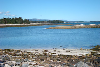
And then, the land opens up to the ocean and it was obvious that we were at Acadia.  The rosey pink rocks, baby blue sky, and salty sea!  The tide was low the day we were there, allowing access to different types of shore; a nice sandy crescent right off the trail, a large expanse of sun-warmed rocks, and an inlet with small rocks just around the corner.


The trails and views are great, and this is a fantastic hike for young and old. Getting there is super easy, too...parking is less than a mile south of Seawall Campground and picnic area on route 102A.

Monday, September 26, 2011

Traveling North Traveler.

When the rest of the East Coast was bracing for Hurricane Irene, we picked up all of the plastic toys in the yard, closed the windows in the house, packed the car, and decided there was enough time to camp at Baxter State Park before the winds and rain blew in. Traveler Mountain is said to be the highest volcanic peak in Maine. 

After a nice evening camping at South Branch Pond Campground, we started up North Traveler. Pogy Notch Trail leaves right from the campground, and squishes over boardwalks and through mud, then over a muddy section, and around a mud puddle before the North Traveler Trail leaves to the left.


The NT Trail is steep and rugged, and after a short slog through hard woods, climbs straight up a jumble of boulders, and sneaks out over the shoulder, to some amazing views of both upper and lower South Branch Pond, and at this point, we turned around; the wind was picking up, we were tired from sleeping in the tent, and remembered how rugged this trail is! But, we enjoyed this part of the hike immensely.

There is a formidable ten mile Travelers Circuit that goes over Traveler.  This is a rugged, hike, and not recommended for little legs (or for inexperienced bigger legs, either).  A great way to see the volcanic remains is to canoe (rent one at the campground for a ridiculous $1 per hour) Lower South Branch Pond, portage (or sneak through the connecting stream if the water is high enough) to Upper South Branch Pond and paddle this quiet section and look up to the east at the comb columns of Traveler Mountain.


This is a spectacular way to experience the North entrance of Baxter State Park.  We are excited to try this hike again when Leah is a little older!

Private Beach!

It is no secret that we love Acadia, the trails, the ocean, the views...ah, especially in the off-season!

One of our favorite hikes is a nice loop that starts just outside the park.  The Hunters Beach Trail is great for a day when you just want to poke around the beach, or take a little longer hike with fantastic views.


The first section of this hike travels through tall pines, over roots and rocks, crosses bridges and boardwalks, and just under a half mile later, walking along little hunter brook, you come to a nice, open, rocky pocket beach.  The brook cuts through the rocky beach, and past a tiny inlet accessible at low tide, and into the rough surf.  This is not a swimming beach, but fun to hear the tide tinkle over the smooth rocks, search the pebbles for sea creatures and climb over the rocky outcrops.


This can be a good enough day by itself, but, for an added adventure, the trail branches up over the cliffs (to the right, facing the beach, to the right just as the trail opens onto the rocky beach).  This adds another half mile (although I think it feels like more awesome stuff than just a half mile) along the cliff, over dry rock, through blueberry patches, and pops out about a half mile down Cooksey Drive.  This makes a nice loop.

This hike is not on the Acadia National Park map. We have a Map Adventures hiking map (from 2005).  But it is easy to find:
Following Route 3 from Bar Harbor, go about three quarters of a mile past Blackwoods campground, take a left onto Cooksey Drive.  The trail head is about a quarter of a mile on the left.  If all four spaces are taken, there is additional parking around the bend.  

Thursday, July 14, 2011

Thrilling Blueberry Ledges

July is a fun time of year in Maine...fewer bugs and almost no chance of snow!

A favorite Baxter hike is a sweet trip to Blueberry Ledges.  This three and a half mile round-trip hike starts out of the park, near Abol Bridge, rather than from the Tote Road. 


The walk starts on the Appalachian Trail, across a bridge over Abol Stream offering a great peek of Katahdin, and along the confluence of West Branch of the Penobscot to a kiosk (sign in).  I spent this first quarter of a mile seriously reconsidering my position on DEET.


At the kiosk, the trail branches right, up the hill and away from the river. We found handfuls of strawberries along this section, so we were surprised when we turned the corner and found ripe blueberries.  The trail meanders along through Birch and Aspen succession growth after a fire in the 70s. 


There are some teaser ledges along the way, and the sound of the hidden stream cascading through the woods builds anticipation, but is no preparation for the awe of the open ledges and the tumbling stream over smooth rocks. 


The day was blue and sunny and we had the place to ourselves; we spent a relaxing afternoon splashing our feet in the stream, picking billions of blueberries, and resting on the smooth, sun-warmed rocks.


Getting there is half the fun: 
From Millinocket center, follow the signs to Baxter State Park, just about 8 miles North on Millinocket Lake Road, the Big Moose Inn and North Woods Trading Post will be on your right, turn left onto cut-through to The Golden Road. Take a right on to the Golden Road and follow just shy of ten miles. Keep your eyes open along the ride, we often see moose in the ponds along this stretch! Just before Abol Bridge (campground and store) on the right is a dirt road that goes up a small but steep hill (if you miss this, turn around at the store, and the road is much more obvious from that direction) and follow the power lines for a couple hundred feet and take the left into the sand pit (there are two brown sheds in the pit). Park here and follow the white-blazed Appalachian Trail away from the road. I would suggest a good map of the area, I don't see any good ones online; we have a deLorme that is very detailed.

Tuesday, June 7, 2011

Ship Harbor


June at the ocean. Nothing like it, except maybe July and August.  And oh, yeah, September, too.  Come to think of it, the ocean offers something cool every month.  But this past weekend, the weather was perfect.


The Ship Harbor Trail at Acadia National Park is one of our faves. The 1.3 mile trail winds through nice woods, opens, to quintesential Acadia rocky shore with tidepools, curls along the serene harbor, down to a small rocky spit with great rock skipping opportunties. The terrain is very easy to walk, has lots to see, and is short enough for little legs to enjoy!


The Ship Harbor Trailhead is just about five miles south of Southwest Harbor, past Seawall, and Wonderland, and the trailhead is on the left.

On the way home, the options are numerous, Beals in Southwest Harbor or Thurston's in Bernard for in-the-rough lobster!  The Dry Dock Cafe in Southwest Harbor is a nice sit-down place if that is .

Acadia National Park map at:  http://www.nps.gov/pwr/customcf/apps/maps/showmap.cfm?alphacode=acad&parkname=Acadia%20National%20Park

We have done this loop scores of times; it was Leah's first Acadia visit when she was just a few weeks old.

Monday, May 9, 2011

Flying High on Flying Mountain

Mother's Day at Acadia; who could ask for anything better?

We decided to revisit Flying Mountain, on "the quiet side" of Mount Desert Island, overlooking Somes Sound.  This is nice little hike with a rocky beach, some good climbing, a nice traverse, and an easy down.

Finding the trailhead is easy, too.  Once on MDI, bear left onto 102 south towards Southwest Harbor; follow approximately 9.5 miles.  Turn left on Fernald Point Road (Causway Golf Club sign at the intersection).  Follow Fernald Point Road for about a mile, the parking area is on the left just after the cove.
 
This is a nice loop trail we have done both directions.  This time, we started on the fire/carriage road rather than the trail.  The road is wide, grassy, lined with cedars, and about half a mile to the ocean.  This nice rocky inlet on Somes Sound has gentle lapping waves and nice views across the water to Seargeant Drive. 

 From the beach, the trail leads up and over Flying Mountain and arrives back at the parking area in just about three quarters of a mile. Walking up the northern side of Flying Mountain, nicely placed stone staris make the ascent very fun for litte legs.

The up is just about a quarter of a mile and the trail traverses the top of the ridge and over some nice exposed rock.  The summit is an unbelievable 284 feet above sea level, but the views over Somes Sound and the open Atlantic are beautiful.  The descent is very short, and bumps over some rocky spots until the nice piney areas drop right into the parking area. 

After the hike, a trip into Southwest Harbor for lobster is fun.  Southwest Harbor is bustling during the summer season when things are open, but if SWH is shut tight, the Town Hill Market heading back on 102 has sandwiches and ice cream! 


This is last year, but I love how much
she grew in just a year!


Monday, March 21, 2011

A Nice Day at Day Mountain

Ah, March in Maine.  Some years we've been skiing on a great base of snow; other years we've been hiking on nearly dry rock.  This year, we've watched the snow melt under torrential rain, and we are anticipating another six or so inches of snow this afternoon.


Fortunately, we have been able to take some advantage of the nice weather and hike at Acadia.

The Day Mountain hike is fantastic for little and big legs alike, it is a great mix of wooded trail, open rock, and carriage roads, all with fantastic Acadia views.


The ascent is about three quarters of a mile on a nice trail that is not very steep or challenging, but very exciting.  The first quarter of a mile is roughly half plank boardwalks; this is a great way to encourage any little hiker!  The rest of the trail moves through nice piney areas and over sunny open rocks with ocean views.  There are options for the walk down - you can either take the same trail back, or the carriage roads wind down the mountain, crossing the hiking trail several times.


Map at http://www.nps.gov/pwr/customcf/apps/maps/showmap.cfm?alphacode=acad&parkname=Acadia%20National%20Park

Getting there is easy:  Follow Route 3 south of Bar Harbor, past Blackwoods Campground and Cooksey Drive.  The parking area is on the left and the trail is on the right.